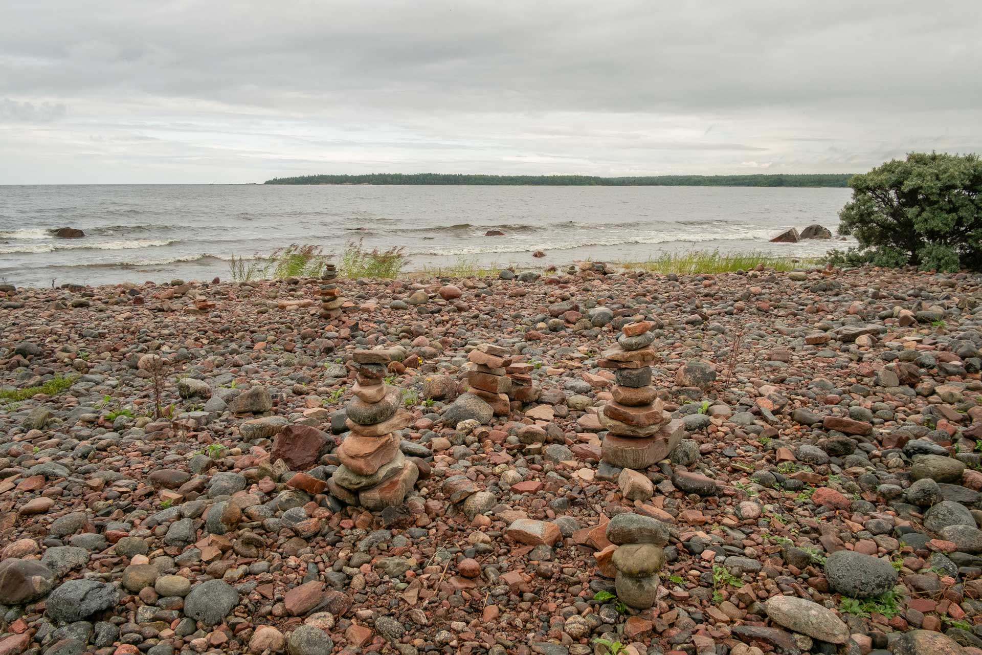
Source: photograph by the author (4 August 2023)
Walking the Line: Exploring a
Perambulatory Research Practice
In Creation of New Knowledge: Dialogues Inside and Between Disciplines, Proceedings Series 2025-1, edited by Anne Elisabeth Toft and Magnus Rönn. Nordic Academic Press of Architectural Research.
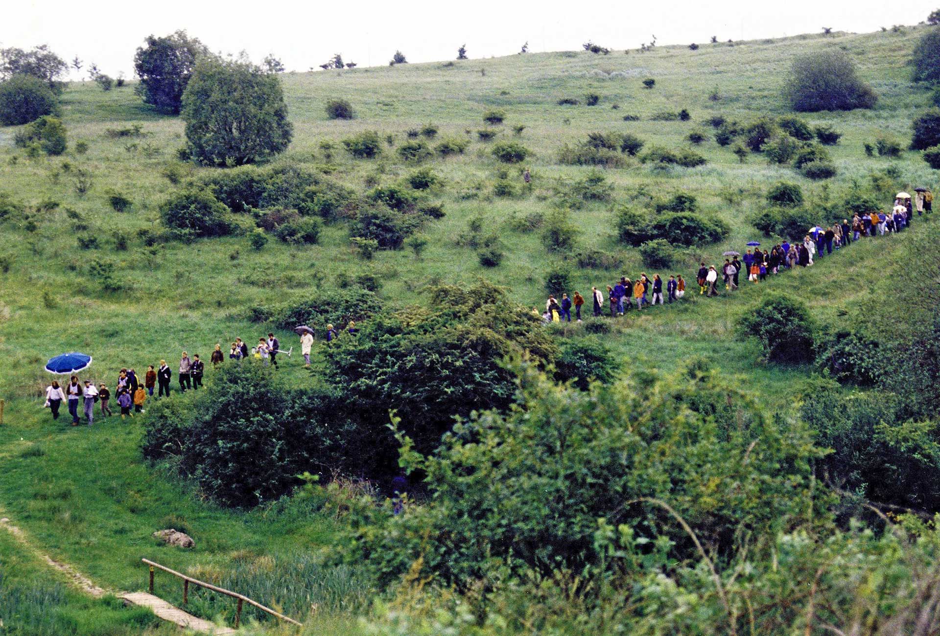
I stand at the end of the line, gazing out across a choppy Baltic Sea. Broken waves greet broken clouds, in a poignant grey symphony. The slim tongue of land I find myself upon gently arcs, before slipping beneath the water, whose constant yet varying rhythms have shaped and manipulated this landscape for millennia. Along the shoreline lie the scattered remains of a rich geologic archive—eroded fragments of limestone, granite, flint, diabase, gneiss and pegmatite—shimmering in lustrous hues of red, blue, black, pink and yellow, enlivened by the effects of sea spray and a light drizzle of rain. Scraggy thickets of sea buckhorn interrupt the otherwise stony ground, with bushels of ripe fluorescent berries clinging to their limbs like salmon roe. A lone woman in a military-green raincoat and knee-high Wellingtons slowly wanders along the water’s edge, occasionally stooping to pick up a pebble—the only other visitor on this drizzly summer’s day.
Billudden, 4 August 2023
Everything Flows
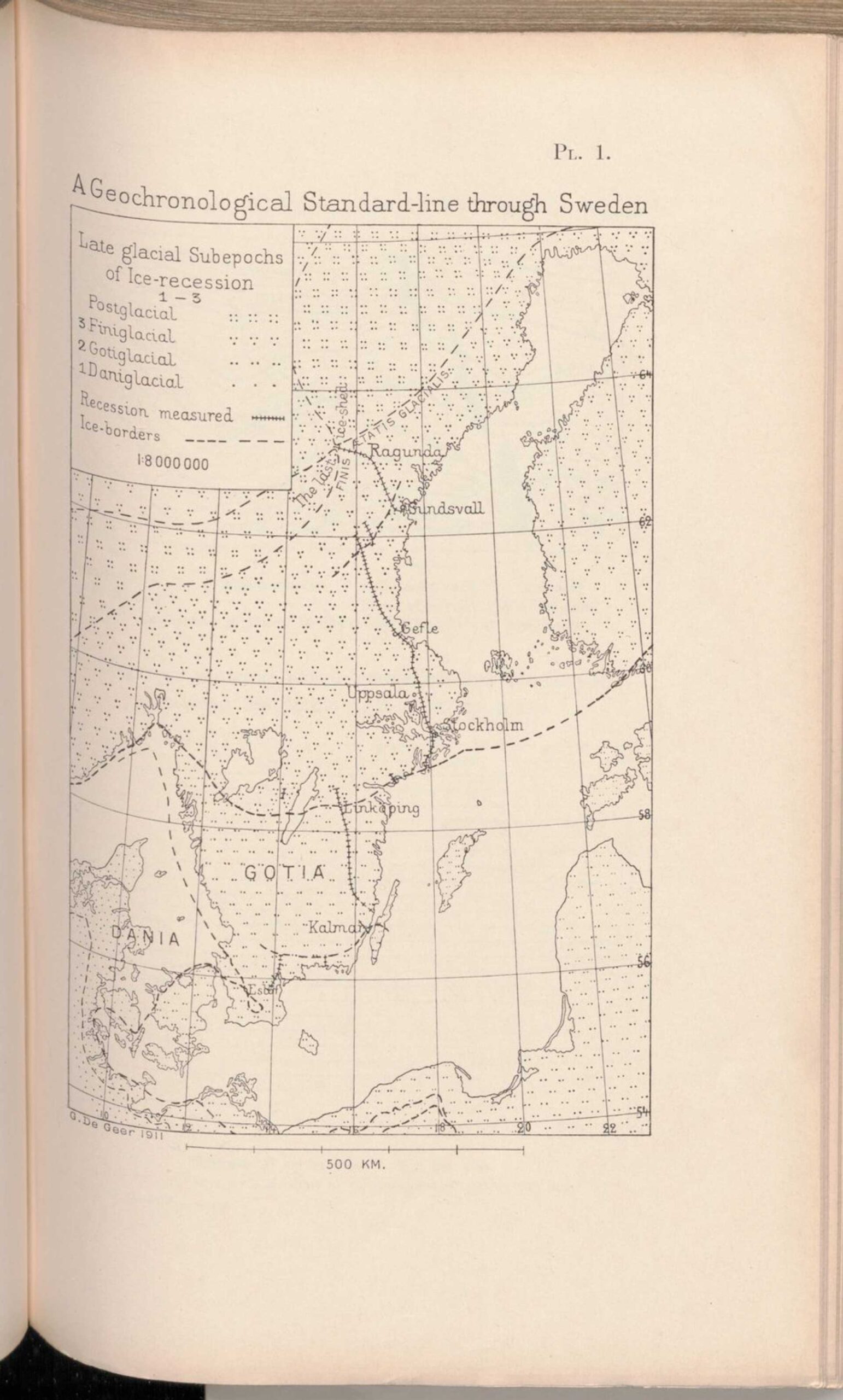
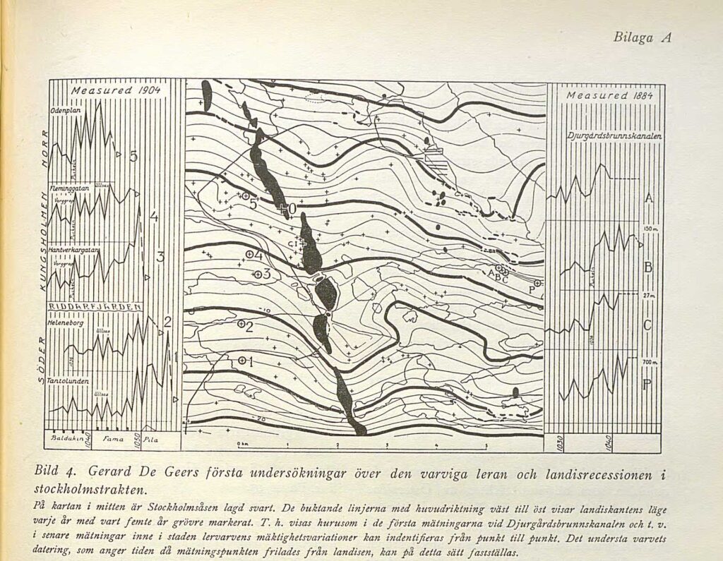
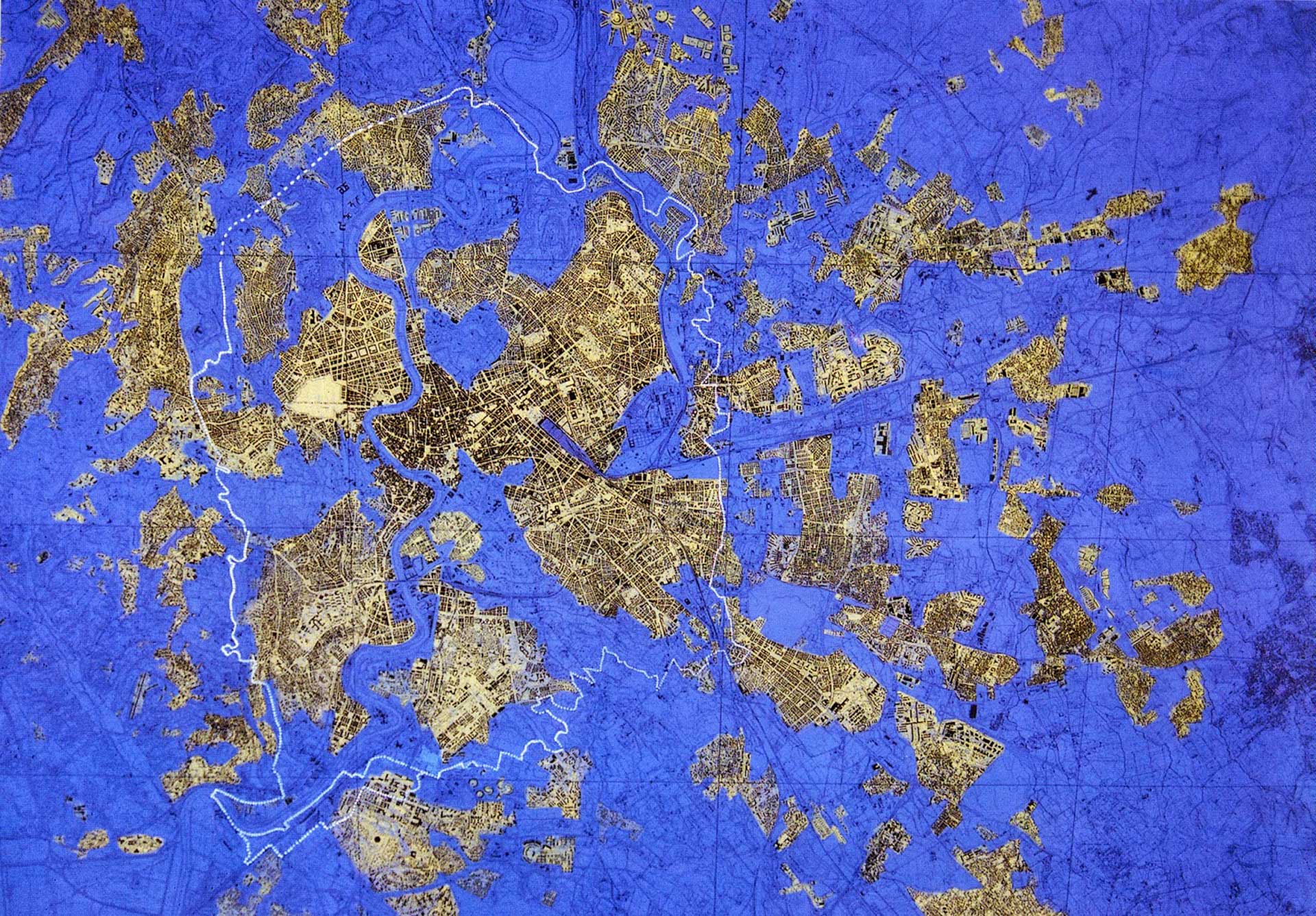
On a summer morning in 1905 the renowned Swedish geologist Gerard De Geer set out with ten students from Stockholm University, and ten from Uppsala University, ‘each of them to their special part of a line about 200 kilometres long, running past Stockholm and Uppsala through the Södermanland-Uppland peninsula, from the great Fennoskandian moraines at its southern end to the Dalälfven River to the north’.[1] Over the next four days the expedition team made detailed observations of laminated fluvio-glacial clay sediments at various points along this line, measuring the distances between the distinctive annual layers. As a student in 1878, De Geer had recognized the regularity of these bands of sediment while conducting fieldwork, noting their similarity to the annual rings of trees and speculated that they must also represent annual layers of accumulation.[2] Over the years that followed he conducted fieldwork at several sites around Stockholm, but it was not until 1904–05 that he attempted to prove his method of counting periodically laminated sediments at sections placed at regular intervals along a line could establish a geochronology of the end of the last ice age. It was an undertaking that would reveal a precise timeline of the climatic changes and geomorphic processes that had moulded the territory surrounding Stockholm, and in subsequent years the entire Scandinavian Peninsula (see fig. 2).[3] De Geer read the earth as a vast territorial archive capable of recounting stories of past climatic upheavals, territorial transformations, and material flows. One simply had to pay attention to the clues left behind.
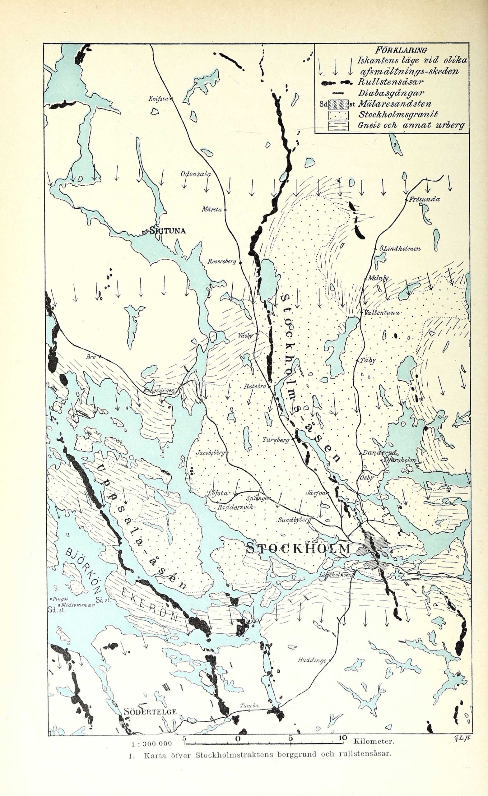
On a wet August day in 2023 I found myself at the end of this line, just to the east of the Dalälven River delta, and the northern limit of the 1905 geologic survey carried out by De Geer and his team of students. I had reached the tip of Billudden, the narrow sandy peninsula that marks the northern limit of Uppsalalåsen, which extends into the Gulf of Bothnia like an index finger (see fig. 1). The ridge is an esker, or os (rullstensås in Swedish), formed during the final stages of the last ice age by glacial debris deposited by the retreating Fenno-Scandian ice sheet. The jumble of stones lining the shoreline had their origins in the mountains to the north, and had been transported to their current location via subglacial streams flowing beneath the kilometre-thick ice mass. The natural terraforming forces previously unleashed here are hard to comprehend, as the power and drama involved in the creation of these post-glacial landscapes are barely perceptible from our temporal point of view. De Geer’s line of investigation traced this esker for much of its northern length, while further south it aligned with the more easterly Stockholmsåsen, following it through the city to its southern extremity around Västerhaninge: a line of inquiry which stretches for some 200 kilometres obliquely across the territory of Stockholm—a line which uncannily aligns with my own path of exploration.
The objective of this article is to unpack the act of walking—perambulation—as a mode of creative research practice, where the line, defined here as the corridor of extraction along Stockholmsåsen and Uppsalaåsen, acts as a situated site of study from which to probe notions of extraction, material flows, land use, territorial transformations, and relations of entanglement. Path-following as Tim Ingold writes is ‘not so much intentional as attentional. It thrusts the follower into the presence of the real. As intention is to attention, therefore, so absence is to presence.’[4] Walking as a creative, generative, and explorative practice becomes the mode from which to enter, experience, and investigate the ‘presence of the real’, which in this case becomes the terrain of the line and its entangled landscapes of extraction. To walk is to be grounded, both partially and subjectively—to be open to the unexpected and the unintended. It is a mode of research which brings experience, perception, and intuition into play, using the body as a sensory recording device to read and transcribe one’s surroundings. This article aims to explore how walking as a creative research practice can contribute to heightening our sense of awareness of the world, and of the multiple entangled social, spatial, and temporal relations at play. How the humble act of walking is able to attune us to the subtle ‘arts of noticing’, to nurture a sense of deep time through instilling a habit of ‘timefulness’, and to gather and narrate alternative ‘spatial stories’, providing a particular, situated point of view that may allow us to imagine other ways of being, and other ways of acting in the world.
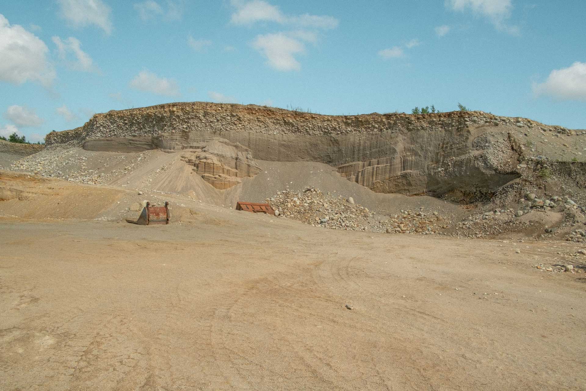
The line acts as a frame of investigation, delimiting the area of exploration to a defined geographic area. The line also functions as a method of research, where walking—tracing the line—becomes a primary mode of exploration. Reaching the tip of the peninsula at Billudden marked the end of my attempt to walk the length of both Uppsalaåsen and Stockholmsåsen in a disjointed, fragmentary manner over a period of several years. It was a journey which took me from the rural hinterlands of Södertörn, through the outer, as well as inner neighbourhoods of Stockholm, across the islands of Lake Mälaren, through the northern suburbs of Solna, Sollentuna, Upplands Väsby, and Bålsta, circumnavigating Arlanda International Airport, past the university city of Uppsala, and north towards the Baltic Sea. A patchwork of walks which in aggregation resemble the geochronological line approximated by De Geer and his students, following the fluvial glacial deposits scattered across the landscape. Material flows produced Uppsalaåsen and Stockholmsåsen as colossal quantities of water, ice, stone, gravel, sand, mud, and clay were pushed across the landscape by glacial and hydrological forces. Today material flows continue to alter and transform the terrain, driven by social, political, and economic forces. The line approximates the major seam of extraction in the Stockholm-Uppsala region, containing dozens of active quarrying operations, which combined, remove millions of tons of sand, gravel, and stone each year, feeding the insatiable demands of the construction industry. Material is dug up, sorted, washed, graded, and transported to one of the many ongoing construction projects throughout the region.
Donna Haraway teaches us: ‘The only way to find a larger vision is to be somewhere in particular,’ urging that we should ‘seek those ruled by partial sight and limited voice—not partiality for its own sake, but, rather, for the sake of the connections and unexpected openings situated knowledges make Possible’.[5] De Geer was able to understand, account for, and illustrate planetary-scale climatic shifts and continent-wide territorial transformations through observations of a particular segment of land close to his home in Stockholm through piecing together combinations of striated earth into a cohesive story. Resource extraction and extractive processes are frequently depicted at a zoomed-out scale, represented by the ‘gods eye view’ from above—the view from nowhere— or through abstract diagrams portraying vast logistical networks, financial flows, and material movements.[6] But what is actually happening on the ground, in the mud and the fine grain that is imperceptible from a distance? What can we learn from paying attention to material flows when situated in the midst of them, from somewhere in particular?
The Arts of Noticing
‘To listen to and tell a rush of stories is a method,’ argues anthropologist Anna Tsing. ‘And why not make the strong claim and call it a science, an addition to knowledge? Its research object is contaminated diversity; its unit of analysis is the indeterminate encounter. To learn anything we must revitalize arts of noticing …’[7] The same could be said of walking as a method— it is a practice which is observational, sensory, and immersive, interested in exploring contaminated diversity and open to the indeterminate encounter. Walking cultivates a patient research approach attuned to the ‘arts of noticing’, of being instinctively conscious of one’s own position and relation to the world. A position which is always grounded, and subjective, aligning with Haraway’s concept of a situated practice, where ‘partiality and not universality is the condition of being heard to make rational knowledge claims. These are claims on people’s lives. I am arguing for the view from a body, always a complex, contradictory, structuring, and structured body, versus the view from above, from nowhere, from simplicity.’[8]
When walking, there is no separation between the mind and the body—both are necessary to navigate and orientate oneself within a space—it is a reciprocal process, as thoughts drive movement, which in turn influences thinking and decision-making in a continuous feedback-loop. As Rebecca Solnit writes, ‘Walking is ideally a state in which the mind, the body, and the world are aligned, as though they were three characters finally in conversation together. … Walking allows us to be in our bodies and in the world without being made busy by them.’[9] Putting one foot in front of the other in a synchronized manner to thrust the body forward in space is a highly refined movement that our species adapted over several million years of evolution—a unique trait that in turn completely transformed us into what we are today. Walking on two feet freed human hands for other tasks, such as tool-making, art, and culture, and, as a consequence, radically expanded the thinking capacity of our minds.[10] Walking is a corporeal act involving a body in motion, and the practice of walking is just that—a practice. It cannot exist solely in a theoretical realm, and although plenty has been written about the theory and practice of walking, the word is no substitute for actually getting out into the world and experiencing it for yourself on foot.
If walking and thinking are inherently connected by reciprocal processes and walking is an embodied, situated practice, then one could also argue that thinking is also situated—we do not think in a vacuum, but generally in the same place as our bodies are located. As Hélène Frichot writes: ‘Thinking takes place somewhere, and it is localized, taking up various bodies and their relations, human, non-human, admixtures of animate and inanimate things, material and immaterial, a rip-tide, a maelstrom that all the while throws out a speculative gesture towards a future.’[11] Frichot uses the concept of ‘thinkables’ to describe the situatedness of thinking and thoughts, borrowing from the philosophical writings of Gilles Deleuze and Isabelle Stengers.[12],[13] A thinkable, according to Frichot, is ‘[i]ndependent of either a given thinker or a fixed object of thought; instead it circulates between both in the midst of an event. … It is less the thought that I have than the thought that strikes me, coming from elsewhere, emerging in the midst of encounter—not “I think” but “something makes me think.”’[14] If it is through the encounter that thoughts strike us—not formulating in the isolation of the mind, but rather already circulating in the world between bodies, objects, and places—then walking is an activity that makes us receptive to the possibility of just such a transformative encounter.
The view from a body is always partial, and subjective, and the body itself is not a static entity, but something that changes, deteriorates, decays. Bodies become exhausted, and it must be noted that walking is an exhausting activity. The feet swell and blister, the calf muscles cramp, the knees quiver, the back aches, the shoulders chafe from the rubbing of backpack straps, the skin suffers from exposure, mosquitos, stinging nestles, and thorny raspberry bushes, the lungs struggle for breath, and the mind empties. Walking twenty or thirty kilometres in one day across rough, uneven terrain is an exhausting activity, yet it somehow also brings about a state of being that is reflected in the exhaustive landscapes of extraction one passes through, or as Solnit writes: ‘The rhythm of walking generates a kind of rhythm of thinking, and the passage through a landscape echoes or stimulates the passage through a series of thoughts.’[15] Exhaustion is not the same as tiredness—when one is tired one thinks of sleep and rest—exhaustion is instead about wakefulness, about anxious restlessness. Exhaustion, according to Frichot, ‘is that which is drawn out, resolving itself in dissolution, or else in the glimmer of some new possibility’.[16] Walking across Stockholm’s zone of extraction one is confronted by the scale of destruction, as vast quantities of earth continue to be removed and dispersed, and the territory is seemingly turned upside-down as ridges are transformed into canyons. However, through being attuned to the arts of noticing, through being immersed and embedded in the local environment-world, other things come into focus—a young deer scurries down a gravel ridge, a fox prowls between idle machines, bouquets of golden wild mustard flowers sprout from recently upturned earth—patches of life unexpectedly thrive amongst the ruins, offering fragments of hope and the glimmer of new possibilities.
Crafting a Habit of Timefulness
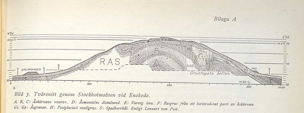
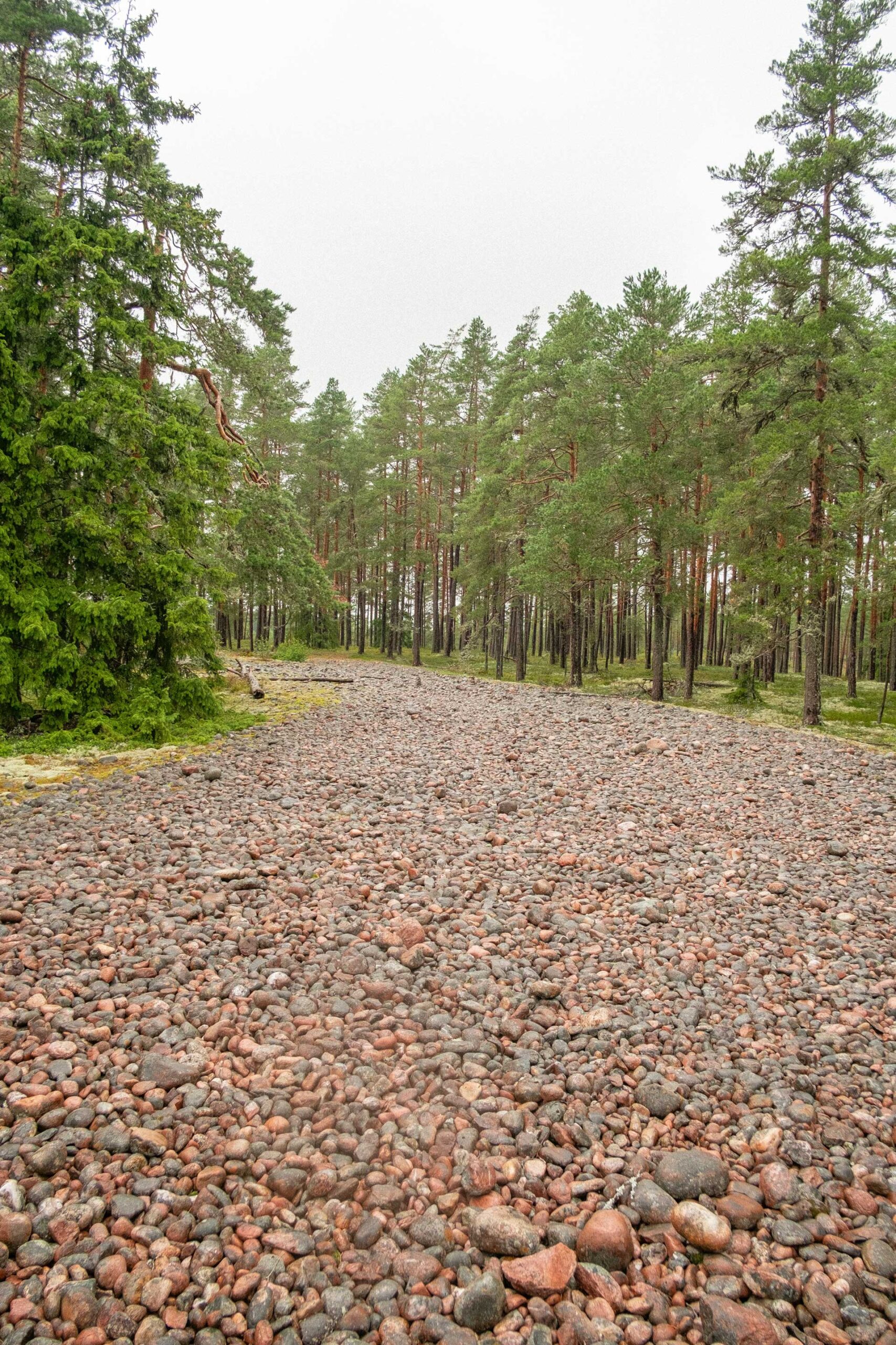
Uppsalaåsen and Stockholmsåsen are distinctly linear geologic features, starting at one point and ending at another, drawing weaving paths between these two locations—they represent the spatial manifestations of deep time, enmeshed within the contemporary urban landscape. Each line has a thickness, a density and weight, sometimes making broad strokes like an ink brush, at other times barely touching the surface like a graphite pencil. Gradients of intensities, extending both vertically and horizontally, with shifting centres and permeable edges. While they appear to depict the continuous meandering path of an ancient river, the ridges represent a series of culminative snapshots of those ancient flows, capturing the moment when the sub-glacial streams breached the steep border of the land ice, and rushed into the sea. As De Geer observed, ‘Thus every ose-centre is nothing else than the proximal glacier-arch portion of an annual layer and, if this is to be compared to a fan, corresponds to the very handle of it. … Thus the whole series of those fans are placed as tiles, one over the other …’[17] The stop-motion composition of these eskers becomes evident at certain points along the line where the ridge suddenly disappears, only to reappear at another location (see fig. 3). The most notable break along Stockholmsåsen occurs south of the city, where the ridge jumps six or seven kilometres to the west between Alta and Enskede, representing a sudden and dramatic shift in position of the fluvial-glacial delta, possibly caused by a localized partial collapse of the ice sheet at some point in the past.[18]
When walking the line, one becomes acutely aware of the multiple temporalities embedded in the landscape, stretching like an elastic band from deep time, through the present, and onwards into an unknown future. Geologist Marcia Bjornerud has termed this form of spatial-temporal perception the ‘habit of timefulness’, a point of view that can offer ‘a clear-eyed view of our place in Time, both the past that came long before us and the future that will elapse without us’.[19] Bjornerud argues that we need to forge a new relationship with time if we are to avoid the catastrophic consequences of unmitigated climate change, astutely noting: ‘The use of the word glacial to mean “imperceptibly slow” is quickly becoming an anachronism; today, glaciers are among the rapidly changing entities in Nature.’[20] To walk along the eskers is to bear witness to the terraforming capacity of climate change, and the unfathomable forces nature previously unleashed upon the land in the not-so-distant past—a time when modern humans were also present. The eskers present a portal to a time when hydro-glacial forces pushed mountains of material across an undulating landscape, moved boulders the size cars hundreds of kilometres, and carved new lakes and watercourses into the terrain. At Viksta, north of Uppsala, a pebbly beach along the crest of the ridge marks the former shoreline, now situated fifty kilometres from the sea—a reminder of the changes this landscape has undergone in a relatively short space of time, and a forewarning of potential climate-induced changes yet to come.
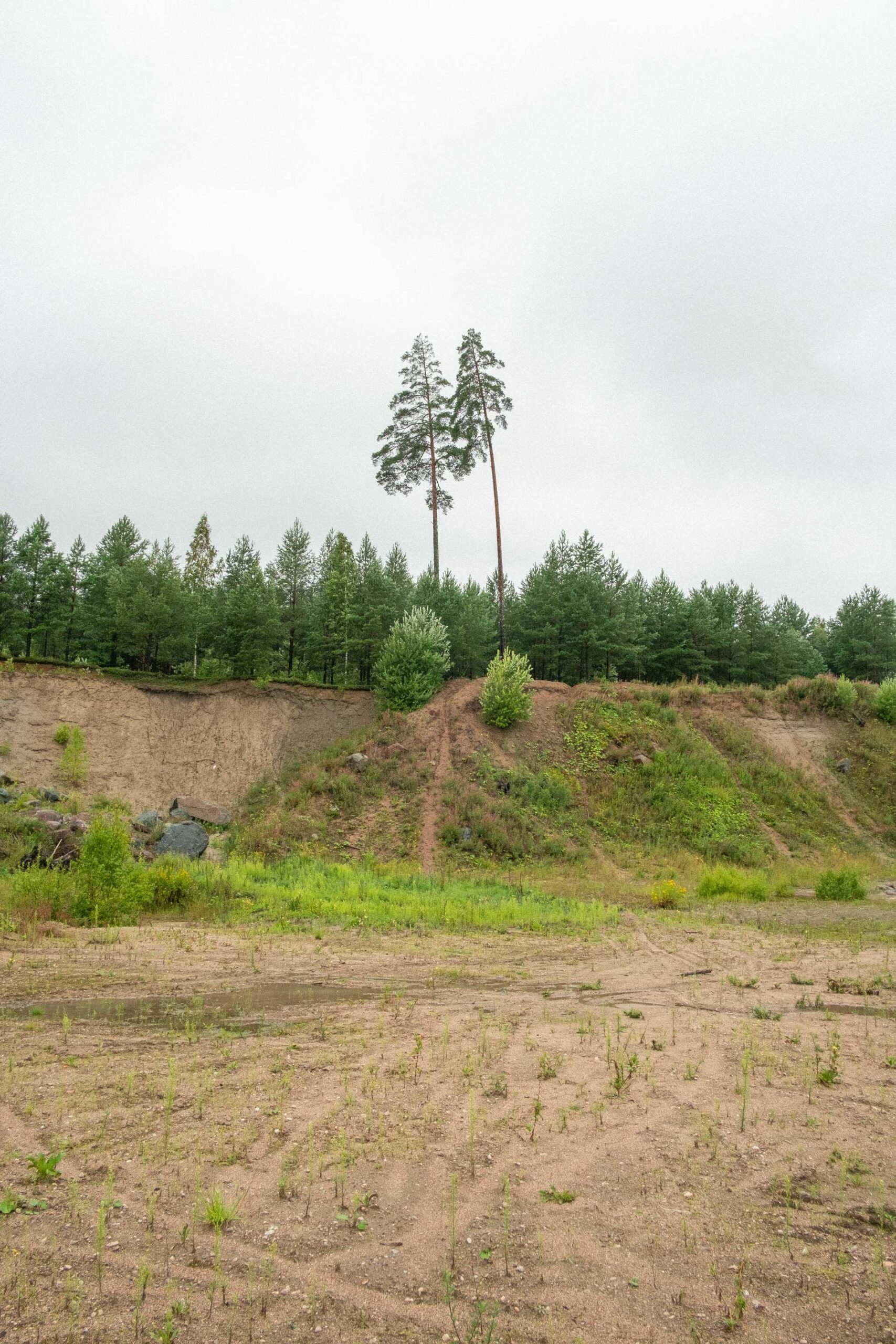
The notion of ‘timefulness’ can also help us to grasp more recent, human-generated territorial alterations. If we can read the territorial history of the landscapes of Stockholm through the post-glacial accumulation of material, we can similarly read a separate layer of urban history through observing this same material’s decumulation and dispersal. As cities expand and grow, so too do their territorial footprints. The quarries, pits, and holes that perforate the length of Stockholmsåsen and Uppsalaåsen could be read as a kind of ghost architecture—voids and absences that correspond to built edifices elsewhere. Landscape architect Jane Hutton terms these spectral territories ‘reciprocal landscapes’, suggesting that for every new construction there is a relational, often distant site of destruction needed to source, process, and transform building commodities. As Hutton writes: ‘While construction materials may appear to be fixed commodities, they are anything but fixed in time, space, or form. Materials change shape as they travel from geological deposit or forest to factory and design project to landfill, passing through human hands and tools.’[21] The eskers of Stockholm were formed gradually through repetitive annual cycles of sedimentation, as a new layer of material was added to previous accumulations each melt-season, yet their alteration by human activities can be read similarly as repetitive cycles of destruction (see fig. 4).
Although produced by natural geological processes, the eskers surrounding Stockholm have been thoroughly altered over centuries through human modification. Large sections of the Stockholm ridge which previously passed through the inner core of the city have been removed completely, with their material diverted towards construction projects, roadworks, and land reclamation efforts (see fig. 5). The scale of these manmade transformations can be observed when walking along Malmskillnadsgatan, which follows the original crest of Stockholmsåsen, running from Brunkerbergstorg to the Church of Saint Johannes. Suddenly the buildings on each side recede, as the road passes above the busy boulevard of Kungsgatan, which was cut through the ridge and opened to traffic in 1911. The archaeologist Matt Edgeworth employs the term ‘humanly modified ground’ to refer to the large amount of the earth’s surface which has, in some way or another, been altered by human activity, encompassing urbanized areas, landfills, earthworks, cut features, mines, quarries, cultivated land, and multiple other examples. According to Edgeworth, all this humanly modified ground represents ‘… part of a single growing entity, which has also been called the “archaeosphere”. This term is useful when considering humanly modified ground on a global scale, as a thin layer interposed between the unmodified geosphere and the atmosphere, intermeshed with the biosphere and the hydrosphere, and forming the material residue part of the technosphere.’[22]
The concept of humanly modified ground, as Thomas Juel Clemmensen explores in a recent study of time-based aesthetics in the port of Aarhus, can aid in ‘sensitizing humans to some of the environmental conditions that characterize the Anthropocene’.[23] Illustrating time-based aesthetics and the processes of erosion and sedimentation by means of a series of found monuments at the port site (directly inspired by Robert Smithson’s A Tour of the Monuments of Passaic from 1967), Clemmensen writes: ‘These processes make it possible to entangle geologic time and address human engagement in geologic processes, which otherwise are too slow or too large to be perceived.’[24] When walking across ‘humanly modified ground’, particularly mines, quarries, and land altered by acts of extraction and excavation, one is confronted with the landscapes of the Anthropocene, and multiple entangled temporalities. The slow creep of deep time becomes perceptible as it rubs against the present, as geologic processes that transformed the landscape over centuries are mimicked by industrial machinery at a frantic pace.
Walking is an effective means of perceiving multiple temporalities in the environment, yet the act of walking itself also has a distinctly temporal quality to it. Walking is a practice which takes time—and in the process makes one acutely aware of time. It is also a practice that leaves fleeting traces behind in the form of footprints, which, as impressions, are slightly different from inscriptions, since they retain a temporal existence and duration, and maintain a relation to the ground of upon which they belong. As Ingold remarks, rather than recording the trace of a gesture, ‘footprints register emplaced movement’.[25] Ingold asks us to consider the difference between drawing and walking, and the contrasting actions between the hands and the feet, where ‘the feet, bearing the full weight of the body, impress the ground rather than inscribing it. Although the movement of walking is continuous, each footfall makes a separate impression. For the path to appear along the ground as a continuous line it must be walked many times, or by many people, so as to iron out the incidence of individual treads.’[26] Footprints mark the movement of an individual, yet if repeated in a sequence will form a track, which if trodden enough may merge into a continuous path, at which time the trace of the individual is replaced by that of the collective, or the social.
The temporo-spatial act of walking might also be understood as having a performative dimension, drawing upon Judith Butler’s distinction between performance and performativity, where performance assumes a subject, whilst performativity contests the notion of a subject altogether. A performance could be understood as an act, such as a play, or a dance, while according to Butler, performativity is ‘not a singular “act”, for it is always a reiteration of a norm or set of norms, and to the extent that it acquires an act-like status in the present, it conceals or dissimilates the conventions of which it is a repetition.’[27] The performative act, as defined by Barbara Bolt, building on the writings of J. L. Austin, ‘doesn’t describe something but rather it does something in the world. This “something” has the power to transform the world.’[28] Performative utterances have real effects. Walking, as a practice and as an action, has real world effects. Imprints on the ground caused by the weight and motion of the body leave footprints, which in turn can become serial arrangements leading to tracks, which if exposed to a continuous flow of pedestrian traffic will develop into the social infrastructure of tracks, paths, and roads. Walking Uppsalaåsen and Stockholmsåsen provides important insights into the performative capacity of walking, and its culminative effects over time. Historically, the eskers served as important transportation routes, connecting early Norse communities across space and time, as evidenced in the abundance of ancient burial mounds and rune stones situated along the line, later complemented by Christian cemeteries, medieval churches, and urban settlements. The main road between Stockholm and the north followed the crests of both Stockholmsåsen and Uppsalaåsen well into the seventeenth century, with the many hollow ways, or sunken lanes carved into the hillside left as reminders of past repetitive movement. While today most major transport arteries no longer follow the crest of the ridge, the main north-south highway, as well as railway lines, still run parallel to Stockholmsåsen south of Uppsala, and to Uppsalaåsen to the north of the city. The performative utterances of a continuous and constant flow of footprints along a narrow linear stretch of land has had significant real-world effects on the social, political, and economic development of the region. The highway is just a further progression of a continuous succession of footprints.
Gathering Spatial Stories
Walking the line—following ancient fluvioglacial flows, as well as contemporary movements of construction materials—becomes a way of knowing the world through experiencing a relation to the places and things in it. It is a form of knowledge gleaned from the ground, felt in the body, and reflected upon in the mind. Walking becomes a method of reinscribing meaning and poetics on ‘place’ through a shift in perspective, of moving from the cartesian ‘gods eye view’ of the architect, planner, or geographer to a more immersive position much closer to the ground. A position where touch, smell, sound, and perception all combine to create a more nuanced understanding of the world. As Tim Ingold writes,
Whereas the Kantian traveller reasons over a map in his mind, the walker draws a tale from impressions in the ground. Less a surveyor than a narrator, his aim is not—as Kant would have it—to ‘classify and arrange’, or ‘to place every experience in its class’, but rather to situate each impression in relation to the occurrences that paved the way for it, presently concur with it, and follow along after. In this sense his knowledge is not classificatory but storied, not totalising and synoptic but open-ended and exploratory.[29]
To walk is to be in relation with the world, and the humans and nonhumans that constitute it, or as Ingold writes: ‘For the walker, movement is not ancillary to knowing—not merely a means of getting from point to point in order to collect the raw data of sensation for subsequent modelling in the mind. Rather, moving is knowing. The walker knows as he goes along.’[30]Walking through space, the body is in constant dialogue with the world around it, yet rarely situated in a fixed or static position—the relationship is dynamic, constantly shifting, and constantly changing. Before becomes after, in front of now behind, across becomes along, as one walks over, across, through, among, around, down, along, and in-between. The spatial relations between the body and the environment-world around it are further highlighted by prepositions indicating direction, time, place, location, and relative position. Yet this constantly fluctuating milieu does not cause confusion to the walker; it is rather through this continuous feedback process that the walker knows the world.
A walker, as Ingold considers, is more like a narrator or a storyteller than a surveyor or geographer, less concerned with grasping the totality of a site or situation, and more interested in weaving meaning and poetics into place.[31] Walking is by its nature open-ended and exploratory, anticipatory of the unknown and unexpected. Walking becomes a mode of collecting and constructing what Jane Rendall refers to as ‘spatial stories’, which act ‘as a theoretical device that allows us to understand the urban fabric in terms of narrative relationships between spaces, times and subjects. The notion of “spatial stories” can be connected to surrealist wanderings, to the situationist dérive as well as to more recent theoretical ideas about nomadology.’[32] Walking as a practice is interested in crafting narrative relationships, of gleaning bits and pieces from the world and putting them into connection with other objects, stories, and ideas. As a practice it is always, partial, fragmentary, and patchy—but this is a positive attribute—constantly obliged to re-orient, re-think, and re-navigate as new information comes into view and new relations are forged.
Walking the length of Uppsalaåsen and Stockholmsåsen I gather and construct spatial stories from the landscape, developing a particular perambulatory research method that is capable of uncovering hidden narratives, material histories, and entangled spatial relations. Walking as a creative-aesthetic practice, as Rendell notes, emerged out of explorations and artistic experiments by the Surrealists, and later the Situationists, but has since been enriched by a diverse and eclectic array of spatial and artistic practitioners and collectives, such as the Roman collective Stalker, who have been exploring walking as a creative research practice for over twenty years.[33] Formed in Rome in the mid-1990s by a group of young, disenfranchised architects and students, Stalker engaged with walking as a mode of architectural practice capable of rediscovering what they define as the ‘Actual Territories’ of the city.[34] In 1995 Stalker completed a multiday walk circumnavigating the urban periphery of Rome, following a route that intentionally avoided built-up areas, and instead plotted a course through the abandoned, neglected, and marginal spaces which constitute a large part of the city. As Lorenzo Romito writes in the ‘Stalker Manifesto’, these territories’ ‘… conscious presence cannot come about by direct experience, they are to be physically witnessed rather than represented. The archive of experience is the only form of mapping possible for these “Actual Territories”.’[35]
Another critical proponent of walking as a method of creative research practice was the Swiss sociologist, economist, and design educator Lucius Burckhardt, who called his particular practice (or science, as he referred to it) of walking ‘Strollology’. According to Burckhardt: ‘Strollology examines the sequences in which a person perceives his surroundings’, providing a method from which one is able to observe, understand, and analyse aspects of the contemporary urban landscape.[36] In a similar, yet less subversive manner than Stalker, Burckhardt understood that the practice of walking had the capacity to reveal otherwise hidden aspects of the built environment, and provide architects and planners with new insights and perceptions enabling them to approach design in a more sensitive and socially embedded way. In 1987 in parallel with documenta 8 in Kassel, Burckhardt demonstrated his concept of Strollology with the collective walking performance The Voyage to Tahiti, which took place at an abandoned military training site on the edge of the city. A group of walkers were led across the semi-feral landscape as an actor read aloud texts from the travel diary of German geographer George Forster, who accompanied Captain Cook on his second voyage of the pacific in 1772.[37] The vivid descriptions of an island paradise set against the lush surroundings of the semirural hinterlands produced a heightened sense of perception among the walkers, as they became attuned and receptive to their surroundings.
Walking is just one of many strategies that offer the potential of engaging with the world as it already is. It’s a strategy which provides a vantage point from which we can begin to rethink, reuse, repurpose, and reimagine the buildings, spaces, and landscapes that already surround us—our collective spatial heritage. Walking, as a creative research practice aligns with Peg Rawes’ concept of relational architectural ecologies, which she defines as:
… the diverse concrete and ephemeral spatiotemporal habits, patterns and rhythms of daily life which individuals, communities and societies develop within their cultural contexts and milieus. They are the critical, poetic, political and ethical strategies and imaginaries through which new spaces and places of occupation and inhabitation can be constructed.[38]
As walkers such as Lucius Burckhardt, Stalker, the Situationists, and others teach, there is much to learn from simply paying attention to the local environment-world that surrounds us. To walk, to roam, to ramble, to wander, to stray, to err—there is something slightly subversive, rebellious, and antagonistic in the act of walking. The word error has its origins in the Latin errare, which means to wander or roam. Errantry—the quality, condition or fact of wandering is often associated with exile, but as Caribbean poet and scholar Édouard Glissant wrote, there is also something emancipatory in the figure of the Errant, in its renouncement of fixed roots: ‘Errant, he challenges and discards the universal. … The thinking of errantry conceives of totality but willingly renounces any claims to sum it up or to possess it.’[39] Errant, as a state of being-in-the-world, informs Glissant’s notion of a ‘poetics of relation’, ‘a poetics that is latent, open, multilingual in intention, directly in contact with everything possible’.[40] Walking along Uppsalaåsen and Stockholmsåsen, following the material, occasionally off the beaten track and through unsanctioned spaces, is a way of experiencing Glissant’s sticky notion of ‘being-in-the-world’ in all its messy and unstable manifestations. It is about being open to the contingent, unexpected, unplanned, and unintentional that constitutes much of the space we inhabit, about resisting generalizations and totalizing perspectives, seeking alternative imaginaries, and paying attention to what is happening on the ground.
Thinking Like an Esker
Perhaps the farmers who did not want to move out of the Sand Counties had some deep reason, rooted far back in history, for preferring to stay. I am reminded of this every April when the pasque-flowers bloom on every gravelly ridge. Pasques do not say much, but I infer that their preference harks back to the glacier that put the gravel there. Only gravel ridges are poor enough to offer pasques full elbow-room in April sun. They endure snows, sleets, and bitter winds for the privilege of blooming alone.[41]
This poetic observation of the blooming patterns of pasque-flowers (pulsatilla vulgaris) by Aldo Leopold can be found in his seminal collection of essays, A Sand County Almanac: And Sketches Here and There, published posthumously in 1949. The pasque-flower is a recurring subject in Leopold’s work, appearing already in the introduction to the volume, where he writes: ‘For us of the minority, the opportunity to see geese is more important than television, and the chance to find a pasque-flower is a right as inalienable as free speech.’[42] The short story of the pasque-flower offers an incredibly rich spatial, temporal, and embodied reading of the wild crocus flowers, providing a detailed account of their spatial habitat on gravelly eskers, situating them within a timeline stretching back to the ice age, and entangling them within the human world of the poor Sand County farmers. A Sand County Almanac could be understood as an early guidebook to the ‘arts of noticing’, teaching us to pay close attention to the subtilties of the world around as—the small shifts in landscape, climate, vegetation, and geology—and a forewarning of the unintended consequences caused by human-induced actions.
While Leopold does not write explicitly about walking as a practice, from his writings it is evident that he was an avid walker, with most of his insights and observations gleaned while on foot, either from around his farm in Wisconsin, or else on other travels through the wild spaces of the United States. In the short essay in part two of the collection titled ‘And Sketches Here and There’, Leopold recalls witnessing the death of a wolf at the hands of hunters, and in a revelatory moment realizing the critical role the species plays in maintaining balance in the ecosystem, writing: ‘The cowman who cleans his range of wolves does not realize that he is taking over the wolf’s job of trimming the herd to fit the range. He has not learned to think like a mountain. Hence we have dustbowls, and rivers washing the future into the sea.’[43] ‘Thinking like a mountain’ might be understood in a similar vein to Glissant’s ‘poetics of relation’, as a particular way of being-in-the-world that entails an understanding and appreciation of the interconnectedness of everything—an awareness of the multiple entanglements between humans, nonhumans, and their spatial surroundings, and a temporal perspective extending beyond the horizon of a human lifetime.
Panta rhei, everything flows—so goes the famous dictum attributed to Heraclitus, the ancient Greek philosopher from Ephesus, and so begins the first sentence of Gerard De Geer’s thesis on the geographic development of Scandinavia after the ice age, Om Skandinaviens Geografiska Utveckling Efter Istiden.[44] Walking, as a perambulatory research practice, offers a situated point of view from which to contemplate, understand, and observe a few of the many entangled relationships latent in the landscape. As I walk the line, following the fluvio-glacial material flows along Stockholmsåsen and Uppsalaåsen, I embrace Leopold’s ecological ethic of ‘thinking like a mountain’, or in this case of ‘thinking like an esker’. Through the practice of paying attention—the arts of noticing—I become keenly aware of the subtle changes in the landscape around me, the humans and more-than-humans that have shaped the environment, and open to the stories and thinkables I may encounter. Cultivating a habit of ‘timefulness’ I become attentive to the multiple temporal scales I pass through and interact with, deciphering the glacial movements of the distant past, yet equally imagining an alternative future beyond the present, and lastly, gathering ‘spatial stories’. I gain knowledge of the word through experiencing it, gleaning new meaning and poetics by revealing the narrative entanglements between spaces, time, and subjects. Everything is interconnected, and everything moves, it is just a matter of seeing the world from a particular point of view, of reading the multiple spatial and temporal stories already embedded in the earth.
* * *
Notes:
[1] Gerard De Geer, ‘A Geochronology of the last 12 000 years’, in Compte Rendu : De La XIe Session Du Congrès Géologique International (Stockholm, 1910), fascicule 1, 1912, p. 241.
[2] De Geer, ‘A Geochronology’, p. 242.
[3] De Geer, ‘A Geochronology’, p. 247.
[4] Tim Ingold, The Life of Lines (New York: Routledge, 2015), p. 133.
[5] Donna Haraway, ‘Situated Knowledges: The Science Question in Feminism and the Privilege of Partial Perspective’, in Feminist Studies, 14/3(Autumn 1988), pp. 579–99, esp. p. 590, https://doi.org/10.2307/3178066 [all URLs here accessed in December 2024].
[6] For various examples of ‘gods eye view’ depictions of extraction and a general critique of visual representations of the Anthropocene, see T. J. Demos, Against the Anthropocene: Visual Culture and Environment Today (Berlin: Sternberg Press, 2017)
[7] Anna Lowenhaupt Tsing, The Mushroom at the End of the World: On the Possibility of Life in Capitalist Ruins (Princeton, NJ: Princeton University Press, 2015), p. 37.
[8] Haraway, ‘Situated Knowledges’, p. 589.
[9] Rebecca Solnit, Wanderlust: A History of Walking (London: Granta, 2001), p. 5.
[10] Solnit, Wanderlust, p. 18.
[11] Hélène Frichot, Creative Ecologies: Theorizing the Practice of Architecture (London: Bloomsbury, 2018), p. 177.
[12] Gilles Deleuze, Difference and Repetition (New York: Colombia University Press, 1994), p. 139.
[13] Isabelle Stengers, In Catastrophic Times: Resisting the Coming Barbarism (Ann Arbor, MI: Open Humanities Press, 2015), p. 131.
[14] Frichot, Creative Ecologies, p. 174.
[15] Solnit, Wanderlust, p. 5.
[16] Frichot, Creative Ecologies, p. 71.
[17] De Geer, ‘A Geochronology’, p. 245.
[18] Erik Fromm, ‘Bilaga A: Stockholmstraktens geologi’, in Generalplan för Stockholm 1952 = A general plan for Stockholm 1952 (Stockholm: Stockholms stadsplanekontor, 1952), p. 422.
[19] Marcia Bjornerud, Timefulness: How Thinking like a Geologist Can Help Save the World (Princeton: Princeton University Press, 2018), p 17.
[20] Bjornerud, Timefulness, p. 131.
[21] Jane Hutton, Reciprocal Landscapes: Stories in Material Movement (New York: Routledge 2020), p. 5.
[22] Matt Edgeworth, ‘Humanly Modified Ground’, in Dominick DellaSala and Michael Goldstein (eds.), Encyclopedia of the Anthropocene (Oxford: Elsevier, 2017), pp. 157–61.
[23] Thomas Juel Clemmensen, ‘Humanly Modified Ground and Time-Based Aesthetics’, in Journal of Landscape Architecture, 17 (2022), p. 46, doi:10.1080/18626033.2022.2110418.
[24] Clemmensen, ‘Humanly Modified Ground’, p. 46.
[25] Ingold, The Life of Lines, p. 63.
[26] Ingold, The Life of Lines, p. 61.
[27] Judith Butler, Bodies that Matter: On the Discursive Limits of Sex (New York: Routledge 1993), p. 12.
[28] Barbara Bolt, ‘A Performative Paradigm for the Creative Arts?’ Working Papers in Art and Design, 5 (2008), p. 8.
[29] Ingold, The Life of Lines, p. 48.
[30] Ingold, The Life of Lines, p. 47.
[31] Ingold, The Life of Lines, p. 47.
[32] Jane Rendell, Art and Architecture: A Place Between (London: IB Tauris, 2007), p. 190.
[33] Rendell, Art and Architecture, p. 190.
[34] Peter Lang, ‘Stalker unbounded: urban activism and the terrain vague as heterotopia by default’, in Heterotopia and the City: Public Space in a Postcivil Society, ed. Michiel Dehaene and Lieven De Cauter (New York: Routledge, 2008), pp. 215–24.
[35] Francesco Careri, Walkscapes: Walking as an Aesthetic Practice (Barcelona: Editorial Gustavo Gili, 2002), p. 166.
[36] Lucius Burckhardt, ‘Strollological Observations on Perception of the Environment and the Tasks Facing Our Generation’, in Writings: Rethinking Man-made Environments: Politics, Landscapes & Design, ed. Jesko Fezer and Martin Schmitz (Vienna: Springer, 2012), p. 239.
[37] Jesko Fezer and Martin Schmitz (eds.), Writings: Rethinking Man-made Environments: Politics, Landscapes & Design (Vienna: Springer, 2012), p. 25.
[38] Peg Rawes (ed.), Relational Architectural Ecologies: Architecture, Nature and Subjectivity (New York: Routledge, 2013), p. 11.
[39] Édouard Glissant, Poetics of Relation, trans. Betsy Wing (Ann Arbor: University of Michigan Press, 1997), p. 47.
[40] Glissant, Poetics of Relation, p. 58.
[41] Aldo Leopold, A Sand County Almanac: And Sketches Here and There (New York: Oxford University Press, 1972), p. 90.
[42] Leopold, A Sand County Almanac, p. 6.
[43] Leopold, A Sand County Almanac, p. 113.
[44] Gerard De Geer, Om Skandinaviens Geografiska Utveckling Efter Istiden (Stockholm: P.A Norstedt och Söner, 1896), p. 5.
Click on the link below to download the Full journal, Creation of New Knowledge: Dialogues Inside and Between Disciplines